Please see below the report from the Mullinaveigue Pure Mile
Mullinaveigue Pure Mile: The changing face of a road, the past revealed
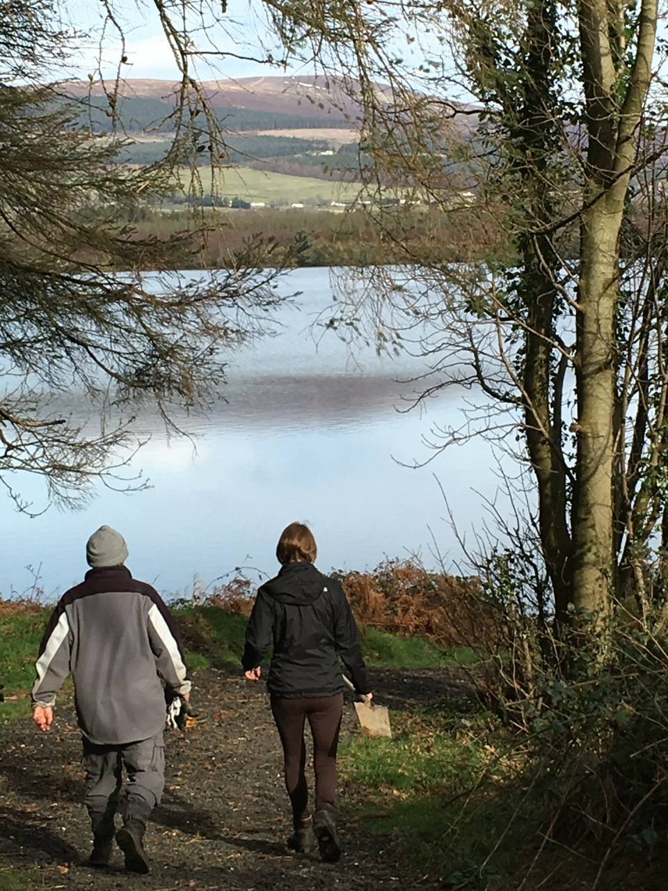
The Mullinaveigue Pure Mile looks like a typical country road. Sadly now it is a race track for fast cars and myriads of cyclists. Both of these have little regard for the residents or other walkers. It would be a major surprise to them to realise the hidden history of the road.
Stories handed down from earlier generations were that Mullinaveigue meant ‘Whey Mill’. A creamery, farrier, and Roundwood’s only shop were all located on the mile!
The first signs of human activity are 3 fulachta fiadh considered to be Bronze Age (c. 2400-500 BC) cooking pits. These are not in what is now the Mullinaveigue townland, but just the far side of the Annacarter river in Shramore! They are in the field about 200m from the road. They are visible only to the trained eye! When these food pits were in use there were no electoral or field boundaries.The natives hunted and fished in the entire area to fill those pots. The Annacarter river still had reasonable size trout in it.
Mullinaveigue townland initially stretched down to far side of the R755 road into an area now flooded by Upper Reservoir. It is hard for us to imagine no reservoir and no R755. It is bounded now by the R755 eastern side, the northern boundary is the Annacarter river and it ends at Bertie’s Triangle. Westerly it extends slightly up hill from the Mullinaveigue Pure Mile
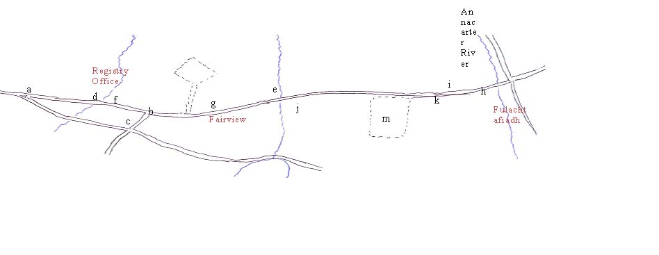
| a | Bertie’s triangle | b | 1798 Holt Memorial | c | Holt’s lane |
| d, e | Bridges | f, g | different stone walls styles | h | Annacarter School & possible 1840s stone wall |
| i | benchmark | j | Millstone | k | forge stone |
| m | Victor’s Way | n | Registry Office marked on 25” OS map as Registry office. In use at least till 1905, but more likely ceased when new State in 1920s. However not mentioned as such in 1901 or 1911 censuses. Described as 1st class dwelling house of William Murphy and wife both described as farmers and Auctioneers. | ||
There is quite a gap in our knowledge about life in the area – about eighteen centuries!
No other known archaeological features so we resort to the written word. Early documents referring to “the lands & territories of the Farrtree (Vartry)” in the early years of the seventeenth century about land being seized from Luke O’Toole’ of Castlekevin. Some of these lands were granted to Sir John Coke. In a letter written in 1636 there is mention of Molenabige (interesting spelling) and Bolincas, a town, hath no wood. Balhinto (Balinastoe), where Mr.Mastserson doth dwell. He is a friend of Mr.Tooles mother, he hath this ……The town hath no wood”. So we know there was already a mill but no wood was seen as a disadvantage due to the developing timber and iron industries.
In 1669 absentee landlords, John Temple, previously Master of the Rolls for Ireland in 1641, and his brother were granted lands in the area by Letters Patent of Charles II. In 1682 the agents for the Temples were recorded “as leasing out the lands of Mullinaveigue and Ballinrush.”.
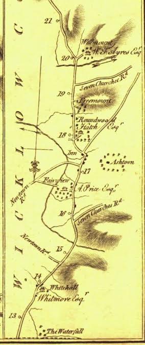
The Taylor and Skinner 1777 Dublin to Rathdrum road map shows our Pure Mile between the mile symbols (o) 16 & 17 from Dublin. Fairview, the residence of Andrew Price Esq. is more or less midpoint of our Mile. There are 4 other houses marked just as squares, no doubt tenants of some standing. The road continues to a very different Roundwood, (most is not there). At Annacarter, there is a road running west to Seven Churches. There is also a road to Newtown from Fairview. R755 was not constructed until 1830s. It is possible that this Newtown road is what we now call “Holt’s Lane”. It still exists crossing the R755 but now ends about 2 fields to the east, relatively close to where the Upper Reservoir dam is today.
It likely one of the houses, on the Fairview estate, was where Joseph Holt (1756 – 1826) lived. His wife Hestor was related to Price. There are no remaining signs of these houses.
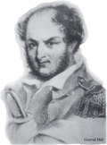
After they married in 1782, he farmed but also held several minor local offices the most notable as a bounty hunter. This did not make him very popular! He was caught up in many feuds. When his house was burnt down by a company of militia, Holt took to the mountains. His wife and young family were looked after by Price.
By then he had joined the United Irishmen and was making a name for himself as a leader. He united the defeated rebels with skill and organized guerrilla resistance. The tales of their endurance in cold and damp, long distances travelled over the mountains and evading capture, all on empty stomachs is better than any historical drama epic seen on our screens.There were even romantic elements–how the wounded Holt travelled over 30 miles, mainly on foot, at night, to see his wife. Another intriguing aspect was the speed of the communication network he had – only word of mouth. Hunted unsuccessfully, Holt eventually surrendered himself on 10 November 1798 on condition of his exile without trial to America, but somehow ended up in New South Wales. His negotiation skills were possibly not the best. [He returned in 1813 and died in Dun Laoghaire]. After 1798, the authorities became more vigilant at controlling minor disturbances and feuds.
Around 1839, the surveyors were triangulating and recording all the details, roads, tracks, houses, field boundaries, water courses, etc. for the 6 inch Ordinance Survey maps in this area. The 25 inch OS map was surveyed later around 1910.
Price’s house, Fairview was marked on the 6 inch OS maps but the house was gone on the 25 inch OS map, just seen as woodland.
In the late 1830s, Samuel Hall and his wife Anna Maria, who were writing the definitive ‘tourist guide’ of Ireland, were on tour in Wicklow. They made scathing remarks about the road from Enniskerry to Rathdrum and the squalor of some of the people seen. It would be assumed they would be on our mile as the R755 was only under construction.
In 1840, Andrew Bourne Esq built Annacarter School and gave it gratis with three acres for his tenant’s children. It was a one storey thatched building with one room (26’ by 13’), two desks and large table. It was run as a non-denominational ‘National School’ following the government scheme introduced in the 1830’s. It remained as such until it closed in 1967.The catchment area for the children was large, including not just Mullinaveigue and Shramore, but Ballinastoe, Carrigower, Glasnamullen, Knockraheen and Slemaine. There was no school bus. Woe betide you if you were late, but you had to get there hail, rain or snow on foot.
There was no connection from the original road as shown by Taylor and Skinner to what is now the R755 until the late 1890s.
The occupation of most parents of the listed enrolled children up to the end of the century were involved in farming, but included gamekeepers, stewards, caretakers, a bailiff, a housekeeper and a charwoman. From the 1900, a change occurred, there were still many parents involved in agriculture but others were navvies, plate layers, engineers, hut keepers, some soldiers and one described as a nobleman! During 1870, the school was also doubled as an agricultural school for older children.
From 1968, the empty building had been acquired by Bill Cunningham, for Ballinastoe Football Club for meetings and training sessions. It was also used also for cards, Scouts, Cubs and Beavers for boys, Brownies and Girl Guides for girls. It fell into disuse in late 1980’s. It was then converted and extended to become a private house in the late 1990’s.
It is possible that the stone boundary wall to the road is original, the construction is so different to the later walls. It could be pre-1840. Certainly the size of the stone suggest field clearance of stones deposited by glaciers during prehistory.
Sycamore trees were planted by the children in 1910, when Tom Donohoe, schoolmaster’s son, was 8 between the school and the old schoolmaster’s house alongside.
The potato famine was worst in 1847 in Roundwood area according to Fr. John Gowan, but we have not found specific references to Mullinaveigue.
Our other resource were the 1901 and 1911 censuses. By 1901 there were 16 dwelling houses, increasing to 18 in 1911. More the half the houses were deemed 2nd class as roofed in thatch, wood or other perishable material. There was a minor improvement in the 10 years, not surprisingly, as there was an influx of workers to build the Upper Vartry Reservoir.
The other intriguing information was the lifestyle, as seen by the outbuildings. An outbuilding was considered to be ‘for domestic or agricultural purposes and should not include outbuildings for Sanitary accommodation such as Privies, ashpits, etc; or for Horticultural purposes such as Conservatories, greenhouses etc; or for Pleasure such as Summer-houses teahouses, etc’.This suggested that running water and internal plumbing were not the norm. However, the outbuildings give a glimpse of a completely different way of life. In both censuses, there were 9 barns, 13 houses had stables, 20 had cow or calf houses, 3 had dairies, 14 had piggeries. In 1901 there was one coach house, 7 fowl houses. By 1911, the coach house was gone but the number of fowl houses increased to 10. Though the number of outbuildings had only increased from 84 to 88 in the ten years, they were used differently, sheds increased from 7 to 11 and stores from none to 21 and there was a forge in 1911.
The piggeries also give an insight into the way of life. Killing a pig was a big communal event even into the 1960’s. The pig was shared with neighbours, some as fresh meat but also there was the preparation of the rashers, bacon and hams – sometimes even as sausages.
Curiously there is no mention of sheep, but in early times, there were non-specific records of wool and clothing inspectors.
By today things have changed dramatically. Currently there are 22 households on the Pure Mile, but only 2 are full-time farmers. Others have to commute distances to work. Victor’s Way is our most extreme example of a different way of life. But the blow-ins who now reside here all bring a fresh perspectives even if they have only blown in from other corners of this island.
What had been the main road from Dublin to Rathdrum is now downgraded to an L road. The upstart new roads are given priority with large signs and even more speeding traffic. Every cloud has a silver lining!